Introducing Parcel Fabric!
At Sentry Dynamics we strive to utilize the latest GIS tools to come up with solutions to create a modern data driven dynamically updated parcel fabric map that replaces static, hard to read and outdated assessor maps. Instead of searching through map images or PDFs, our system zooms directly to the exact parcel fast, precise, and effortless.
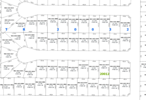
Outdated assessor maps often rely on legacy measurement systems and static PDFs that can become inaccurate over time, leading to boundary discrepancies and inefficient parcel searches. Our modern data driven GIS parcel fabric map leverages current ArcGIS data to deliver precise, continuously maintained property boundary measurements with parcel-level accuracy. This ensures customer service teams and title professionals have fast access to reliable, high-quality property details they can trust.
Features include:
Property measurements |Lot #| Lot SQFT | Plat Name |Block
Don’t miss what’s next. Follow us on LinkedIn for new releases and expansion news!
https://www.linkedin.com/company/sentry-dynamics-inc-